 |
|
|
| You will find below a list of hiking paths into the bosnian mountains, we tried for each of them to provide maps and explanations. |
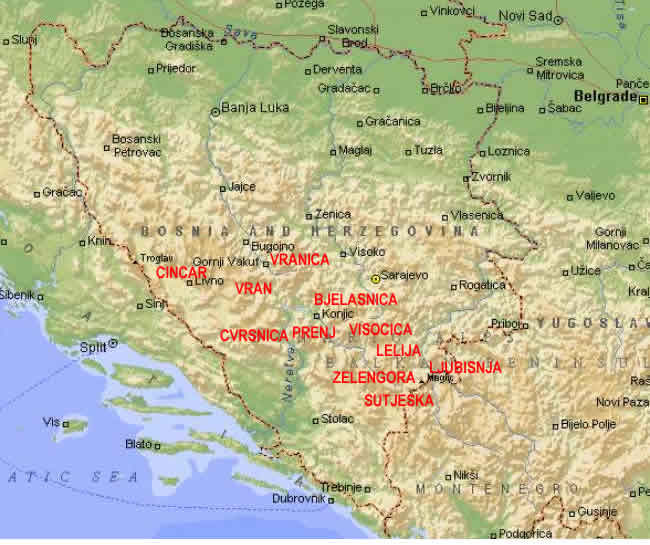
 Bjelasnica Bjelasnica
 Maps Maps
Download [JPEG 5.2M] - Bjelasnica/Visocica - excellent quality
Download [JPEG 3.6M] - Bjelasnica (North East/Center) - scanned, good quality
Download [JPEG 2.3M] - Bjelasnica (North West/Center) - scanned, bad quality
Download [JPEG 3.3M] - Bjelasnica/Visocica mines risk - excellent quality
   » Bjelasnica pictures » Bjelasnica pictures
Visocica
| Name | Rating | Altitude | Difficulty | Orientation | Deniv. | Distance | |
| | | | | | | |  Dzamija summit Dzamija summit |  | 1967 m | | | 670 m | 9.8 km | | | | | | | | | |
Maps
Download [JPEG 5.2M] - Visocica/Bjelasnica - excellent quality
Download [JPEG 3.3M] - Visocica/Bjelasnica mines risk - excellent quality
   » Visocica pictures » Visocica pictures
Prenj
Maps
Download [JPEG 3.1M] - Center Prenj - scanned, good quality
Download [JPEG 8.3M] - Konjic area - scanned, good quality
Download [JPEG 1.5M] - West Prenj - scanned/fixed with several maps, low quality
   » Prenj pictures » Prenj pictures
Orientation : if the orientation is difficult, the rate is low.
Difficulty : A low rating means an easy hike.
Main rating : How we enjoyed this hike (beautiful landscapes, ...). |
|